Sell or Auction Your Lewis Evans General Map of The Middle British Colonies Map for up to Nearly $125,000 or More at Nate D. Sanders Auctions
FREE VALUATION. To buy, auction, sell or consign your Lewis Evans General Map of The Middle British Colonies map that is for sale, please email your description and photos to [email protected] of Nate D. Sanders Auctions (http://www.NateDSanders.com).
Sell Your Lewis Evans General Map of The Middle British Colonies Map
Below are some recent realized prices for a Lewis Evans General Map of The Middle British Colonies map. We at Nate D. Sanders Auctions can obtain up to these amounts or more for you:
Lewis Evans General Map of The Middle British Colonies Map. Sales between Over $100,000 and Nearly $125,000.
The following are some items we sold:
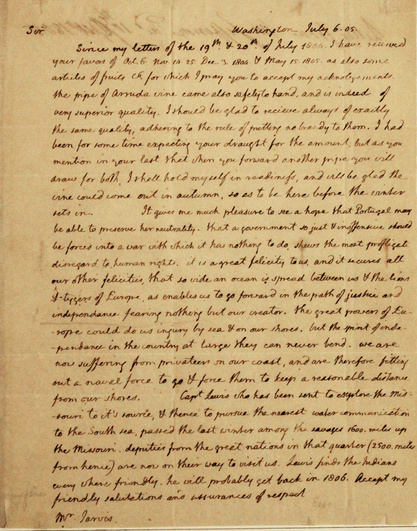
Thomas Jefferson Handwritten Report as President Regarding the Lewis & Clark Expedition — “…Capt. Lewis who has been sent to explore the Missouri to its source & thence to pursue the nearest water communication to the South sea, passed the last winter among the savages 1600 miles up the Missouri. Deputies from the great nations in that quarter (2500 miles from hence) are now on their way to visit us. Lewis finds the Indians every where friendly. He will probably set back in 1806…”
Exceptional, museum-worthy report, handwritten by Thomas Jefferson as President, regarding the Lewis and Clark Expedition. Letter is addressed to William Jarvis of the U.S. consul in Lisbon, Portugal, dated 6 July 1805, describing the historic expedition that Jefferson authorized during his Presidency. In its entirety: “Sir / Since my letters of the 19th & 20th of July 1804 I have received your favors of Oct. 6 Nov. 14-25 Dec. 3 1806 & May 15 1805. As also some articles of fruits & for which I may you accept my acknowledgments. The pipe of Arruda vine came also safely to hand, and is indeed of very superior quality. I should be glad to receive always of exactly the same quality, adhering to the rule of putting no brandy to them. I had been for some time expecting your draught [draft] for the amount; but as you mention in your last that when you forward another pipe you will draw for both, I shall hold myself in readiness, and will be glad the vine would come out in autumn, so as to be here before the winter sets in. It gives me much pleasure to see a hope that Portugal may be able to preserve her neutrality. That a government so just & inoffensive should be forced into a war with which it has nothing to do shows the most profligate disregard to human rights. It is a great felicity to us and it secures all our other felicities, that so wide an ocean is spread between us & the lions & tygers of Europe, as enables us to go forward in the path of justice and independence fearing nothing but our creator. The great powers of Europe could do us injury by sea & on our shores. But the spirit of independence in the country at large they can never bend. We are now suffering from privateers on our coast, and are therefore fitting out a naval force to go & force them to keep a reasonable distance from our shores. Capt. Lewis who has been sent to explore the Missouri to its source & thence to pursue the nearest water communication to the South sea, passed the last winter among the savages 1600 miles up the Missouri. Deputies from the great nations in that quarter (2500 miles from hence) are now on their way to visit us. Lewis finds the Indians every where friendly. He will probably set back in 1806. Receipt my friendly salutations and assurances of respect.” Document measures 8″ x 10″ on two pages, with integral fly-leaf addressed to Jarvis in the hand of Jefferson’s secretary. Toning and folds throughout, with minor tape residue at top and a tiny chip at lower right corner. Near fine condition with bold, legible handwriting. An important piece of handwritten history by the President who commissioned America’s greatest exploration adventure. ADDITIONAL INFORMATION: A near exact copy of this letter resides in the Library of Congress’ Thomas Jefferson Papers. One of the two letters was produced by Jefferson’s polygraph machine (used from 1804 until his death), which provided an immediate copy of his handwritten letters. Though impossible to determine which copy was produced by the pen that Jefferson held, Jefferson typically kept the machine-produced letter as a copy for himself. Since this letter was mailed to William Jarvis (unlike the letter in the LOC), it’s probable that this letter was the one handwritten by Jefferson. Sold for $226,871.
Revolutionary War Map 1776
Revolutionary War map dated March 1776. “The Theatre of War in North America, With the Roads and a Table of the Distances…” Printed in London for R. Sayer and J. Bennett. Map depicts the area east of the Mississippi River from James Bay to Cape Canaveral, and locates provincial boundaries, towns, forts, roads, Indian villages, New England fishing waters, and the like. An inset is comprised of “Evan’s Polymetric Table of America,” which allows one to calculate the distance between most of the prominent towns. Text below the map reads, “A Compendious Account of the British Colonies in North America,” which devotes a paragraph of description to each of the North American colonies, including Florida, Canada, and the Province of Quebec. Issued separately by Sayer and Bennett, who also published “the American Military Pocket Atlas,” that year for the use of British officers. A notable map of the American Revolution, published the same year as the American Declaration of Independence. 20.75″ x 28.5″; 29.25″ x 37.5″ framed. Excellent condition. Sold for $6,000.

Consign your Lewis Evans General Map of The Middle British Colonies at Nate D. Sanders Auctions. Send a description and images of your Lewis Evans General Map of The Middle British Colonies to us at [email protected].
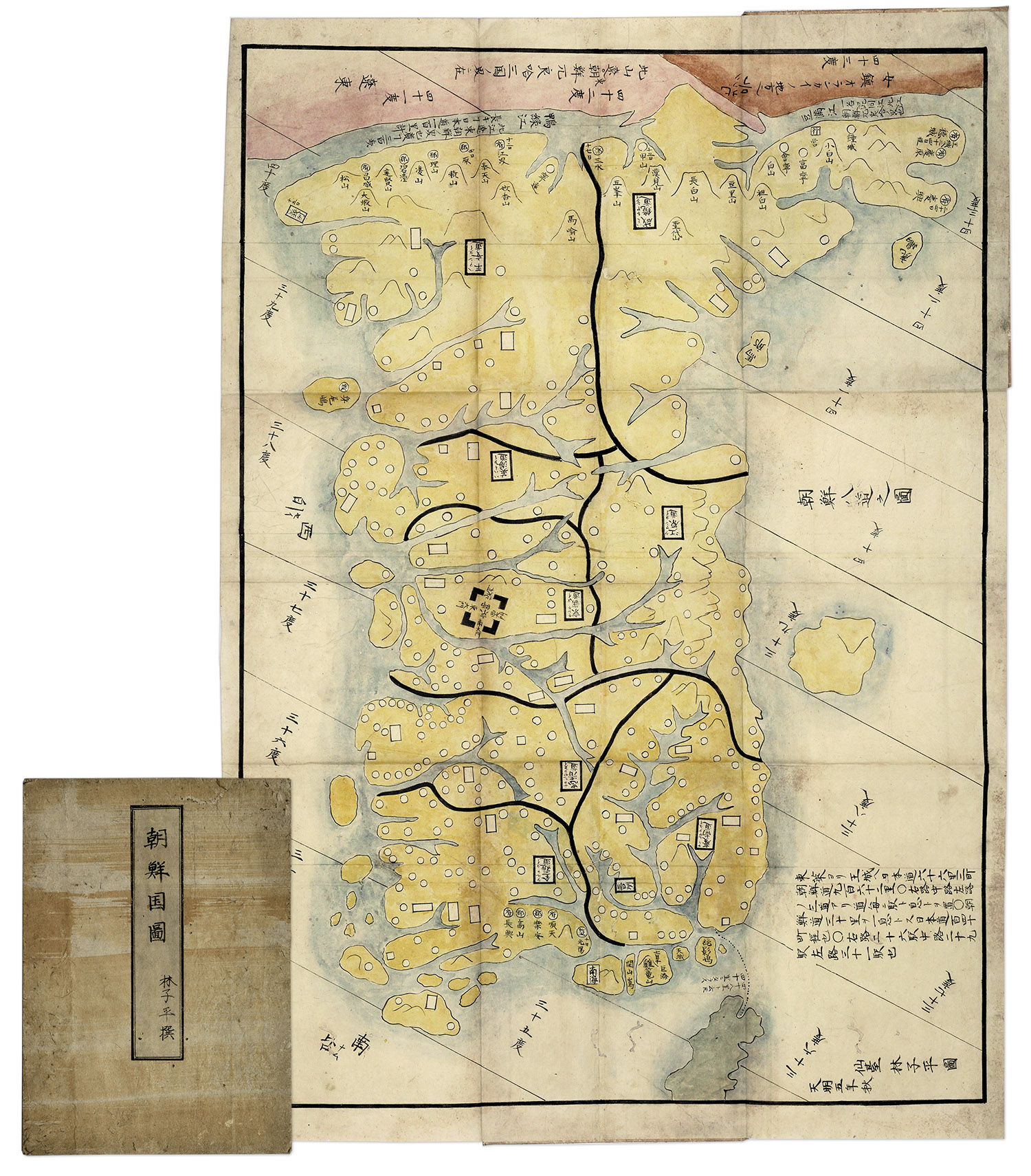
Hand-painted map of Korea by Hayashi Shihei, from Japan, circa 1785. Fold-out map shows the kingdoms outside Japan’s boundaries, but with the Kingdom of Joseon (Korea) being an important trading partner, the map was considered dangerous, and consequently banned by the Shogun in 1792. Has original cover boards and title slip. Measures 20” x 29” when folded out, and 7” x 9.5” when closed. Lightly toned and soiled, overall very good condition. Sold for $1,563.
FREE VALUATION. To buy, auction, sell or consign your Lewis Evans General Map of The Middle British Colonies map that is for sale, please email your description and photos to [email protected] of Nate D. Sanders Auctions (http://www.NateDSanders.com).
We offer the following services for your Lewis Evans General Map of The Middle British Colonies map:
- Appraise Evans General Map of The Middle British Colonies.
- Auction Evans General Map of The Middle British Colonies.
- Consign Evans General Map of The Middle British Colonies.
- Estimate Evans General Map of The Middle British Colonies.
- Sell Evans General Map of The Middle British Colonies.
Connect with us