Sell or Auction Your Plan of the Siege of Yorktown in Virginia London 1794 for up to Nearly $734 or More at Nate D. Sanders Auctions
FREE ESTIMATE. To buy, auction, sell or consign your Plan of the Siege of Yorktown in Virginia London 1794 that is for sale, please email your description and photos to [email protected] of Nate D. Sanders Auctions (http://www.NateDSanders.com).
Sell Your Plan of the Siege of Yorktown in Virginia London 1794
Here is a Plan of the Siege of Yorktown in Virginia London 1794 engraving that we sold:
“Siege of Yorktown” Engraving 1794
Copperplate engraving entitled, “Plan of the Siege of Yorktown in Virginia.” Engraved for Stedmans History of the American War, London, 1794. Text reads, “References. / A. Redoubt taken by assault on the 14th Oct. at Night by the Americans. / B. Redoubt taken by assault on the 14th Oct. at Night by the French.” Hand-colored engraving handsomely framed and matted for display. Map measures approximately 13″ x 11.25″; 23.5 x 21.25 framed. Excellent condition. Sold for $734.

We also sold the following items:
Revolutionary War Map 1776
Revolutionary War map dated March 1776. “The Theatre of War in North America, With the Roads and a Table of the Distances…” Printed in London for R. Sayer and J. Bennett. Map depicts the area east of the Mississippi River from James Bay to Cape Canaveral, and locates provincial boundaries, towns, forts, roads, Indian villages, New England fishing waters, and the like. An inset is comprised of “Evan’s Polymetric Table of America,” which allows one to calculate the distance between most of the prominent towns. Text below the map reads, “A Compendious Account of the British Colonies in North America,” which devotes a paragraph of description to each of the North American colonies, including Florida, Canada, and the Province of Quebec. Issued separately by Sayer and Bennett, who also published “the American Military Pocket Atlas,” that year for the use of British officers. A notable map of the American Revolution, published the same year as the American Declaration of Independence. 20.75″ x 28.5″; 29.25″ x 37.5″ framed. Excellent condition. Sold for $6,000.

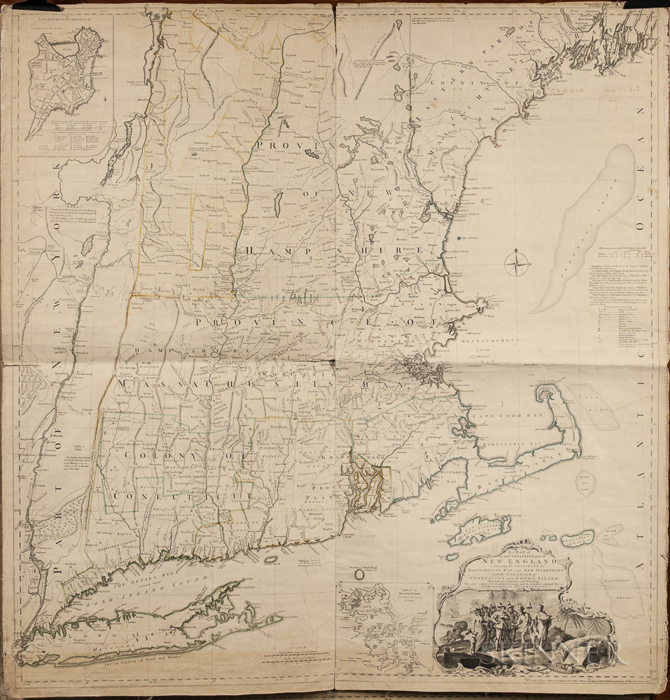
1774 Map of New England measuring over 40” square, the earliest large scale map of the New England colonies and used in the American Revolution. Drawn by Braddock Mead, and originally published in 1755, this copy was included in Thomas Jefferys’ ”American Atlas”, with hand-outlines. London: Printed and sold by R. Sayer and J. Bennett, 1776 (map dated 1774). Entitled in full, ”A Map of the Most Inhabited Part of New England Containing the Provinces of Massachusetts Bay and New Hampshire, with the Colonies of Connecticut and Rhode Island, Divided into Counties and Townships: The whole composed from Actual Surveys and its Situation adjusted by Astronomical Observations.” Measures 40” x 41.25”. Folded in fourths, as printed by copper-plate engraving on laid paper, mounted to linen. Light toning, chipping along margins and separation starting along folds. Overall in very good condition, a bright copy ideal for framing. Sold for $1,875.
FREE ESTIMATE. To buy, auction, sell or consign your Plan of the Siege of Yorktown in Virginia London 1794 that is for sale, please email your description and photos to [email protected] of Nate D. Sanders Auctions (http://www.NateDSanders.com). Top dollar obtained for your Plan of the Siege of Yorktown in Virginia London 1794.