FREE APPRAISAL of your Bernard Romans Map at Nate D. Sanders Auctions
Bernard Romans Map
FREE APPRAISAL of your BERNARD ROMANS MAP. A Bernard Romans map, especially of Connecticut or Florida, is very rare and prices in the five or six figures at auction or if for sale privately. In 2018, a Bernard Romans map, Connecticut and parts adjacent, sold for $37,500 at auction. The Bernard Romans map, Connecticut and parts adjacent, appears to be housed at Stony Brook University. If you have the Bernard Romans map, Connecticut and parts adjacent, it is worth up to $40,000 to our auction house, Nate D. Sanders Auctions (http://www.NateDSanders.com), if you would like to consign it. We at Nate D. Sanders Auctions (email [email protected] or phone 310-440-2982) can be reached each weekday during Pacific business time hours. The Bernard Romans rare Florida book with many a Bernard Romans map, A Concise Natural History of East and West Florida; Containing An Account of the natural Produce of all the Southern Part of British America, in the three Kingdoms of Nature, particularly the Animal and Vegetable, sold for almost $125,000 at auction. We, can also obtain up to that amount or more at our auction. Please let us know if you have a Bernard Romans map for sale.
Speaking of mapping the United States, we at Nate D. Sanders Auctions (http://www.NateDSanders.com), also sold (similar to a Bernard Romans map):
Lot #360:
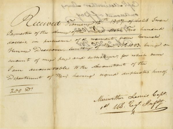
Meriwether Lewis 1807 Document Signed Related to the Famed Lewis & Clark Expedition — Lewis Receives 5 Months Pay From the Expedition Upon Returning to D.C.
certain as seen by ourselves…” (”History of the Expedition,” 1814). In the months immediately preceding the expedition, Lewis sought training in the use of astronomical instruments and in the art of map-making. He also chose a companion officer, William Clark of Louisville. While the expedition did not achieve the primary objective of finding the elusive Northwest Passage, it contributed significantly to the understanding of the geography of the Northwest and produced approximately 140 maps, the first accurate maps of the area. In addition, it documented 100 newly discovered species of animals, approximately 170 plants, and it also established friendly relations with three dozen Indian tribes. The knowledge they obtained sparked American interest in the west, and strengthened the nation’s claim to the area. Meriwether Lewis returned to Washington, D.C. from his three year journey in late December of 1806. After returning from the expedition, Lewis received a reward of 1,600 acres of land. In addition, Thomas Jefferson appointed him Governor of the Louisiana Territory. However, Lewis was not confirmed by the Senate until March 1807 and he remained a Captain in the interim. Base pay for Captains at this period was $40 per month so the present receipt would represent five months’ salary. A supremely rare document directly linking Meriwether Lewis to the Lewis & Clark Expedition. Items of Lewis & Clark related to the famed expedition are of the utmost rarity. Docketed on verso. Toning to folds and showthrough, otherwise near fine condition. Sold for $30,768.
FREE APPRAISAL of your BERNARD ROMANS MAP. A Bernard Romans map, especially of Connecticut or Florida, is very rare and prices in the five or six figures at auction or if for sale privately. In 2018, a Bernard Romans map, Connecticut and parts adjacent, sold for $37,500 at auction. The Bernard Romans map, Connecticut and parts adjacent, appears to also be housed at Stony Brook University. If you have the Bernard Romans map, Connecticut and parts adjacent, it is worth up to $40,000 to our auction house, Nate D. Sanders Auctions (http://www.NateDSanders.com), if you would like to consign it. We at Nate D. Sanders Auctions (email [email protected] or phone 310-440-2982) can be reached each weekday during Pacific business time hours. The Bernard Romans rare Florida book with many a Bernard Romans map, A Concise Natural History of East and West Florida; Containing An Account of the natural Produce of all the Southern Part of British America, in the three Kingdoms of Nature, particularly the Animal and Vegetable, sold for almost $125,000. We, can also obtain up to that amount or more at our auction. Please let us know if you have a Bernard Romans map for sale.
- Appraise Bernard Romans map.
- Consign Bernard Romans map.
- Auction Bernard Romans map.
- Sell Bernard Romans map.
- Buy Bernard Romans map.


Connect with us