Sell or Auction the Map of Parts of Kansas, Texas, Colorado, New Mexico and the Indian Territory for up to $45,000 or More at Nate D. Sanders
FREE APPRAISAL of your “Map of Parts of Kansas, Texas, Colorado, New Mexico and the Indian Territory, with the routes of all columns of U.S. troops operating against hostile Indians in the Department of the Missouri during the winter of 1868–1869” which is a map where the trail of the Seventh Cavalry is illustrated by Captain Henry Elijah Alvord. Email [email protected]. The map last sold for over $40,000 at auction. We at Nate D. Sanders Auctions (http://www.NateDSanders.com) can obtain up to $45,000 for you or more for your “Map of Parts of Kansas, Texas, Colorado, New Mexico and the Indian Territory, with the routes of all columns of U.S. troops operating against hostile Indians in the Department of the Missouri during the winter of 1868–1869”. Please email your photos and description to [email protected].
Top dollar is obtained for your “Map of Parts of Kansas, Texas, Colorado, New Mexico and the Indian Territory, with the routes of all columns of U.S. troops operating against hostile Indians in the Department of the Missouri during the winter of 1868–1869”.
Please let us know if you have a “Map of Parts of Kansas, Texas, Colorado, New Mexico and the Indian Territory, with the routes of all columns of U.S. troops operating against hostile Indians in the Department of the Missouri during the winter of 1868–1869” for sale.
“Map of Parts of Kansas, Texas, Colorado, New Mexico and the Indian Territory, with the routes of all columns of U.S. troops operating against hostile Indians in the Department of the Missouri during the winter of 1868–1869”
Seventh Cavalry Sold by Nate D. Sanders Auctions:
Lot #979:
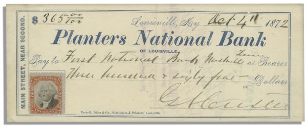
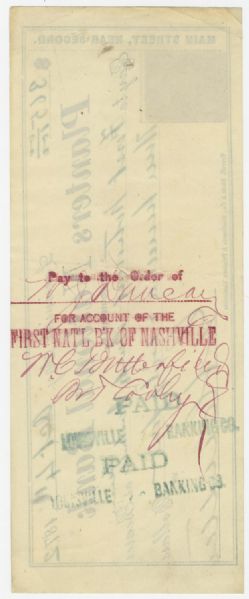
Exceedingly Rare George Custer Check Signed — Dated 1872
Exceedingly Rare George Custer Check Signed — Dated 1872 / Click above for larger image.
FREE ESTIMATE. To auction, buy, consign or sell your “Map of Parts of Kansas, Texas, Colorado, New Mexico and the Indian Territory, with the routes of all columns of U.S. troops operating against hostile Indians in the Department of the Missouri during the winter of 1868–1869”, please email your photos and description to [email protected] of Nate D. Sanders Auctions (http://www.NateDSanders.com) for a FREE APPRAISAL.
Please let us know if you have a “Map of Parts of Kansas, Texas, Colorado, New Mexico and the Indian Territory, with the routes of all columns of U.S. troops operating against hostile Indians in the Department of the Missouri during the winter of 1868–1869” that is for sale. Top dollar is procured for your “Map of Parts of Kansas, Texas, Colorado, New Mexico and the Indian Territory, with the routes of all columns of U.S. troops operating against hostile Indians in the Department of the Missouri during the winter of 1868–1869”.
Nate D. Sanders Auctions offers the following services for your Captain Henry Elijah Alvord “Map of Parts of Kansas, Texas, Colorado, New Mexico and the Indian Territory, with the routes of all columns of U.S. troops operating against hostile Indians in the Department of the Missouri during the winter of 1868–1869”:
- Appraise “Map of Parts of Kansas, Texas, Colorado, New Mexico and the Indian Territory, with the routes of all columns of U.S. troops operating against hostile Indians in the Department of the Missouri during the winter of 1868–1869”.
- Consign “Map of Parts of Kansas, Texas, Colorado, New Mexico and the Indian Territory, with the routes of all columns of U.S. troops operating against hostile Indians in the Department of the Missouri during the winter of 1868–1869”.
- Auction “Map of Parts of Kansas, Texas, Colorado, New Mexico and the Indian Territory, with the routes of all columns of U.S. troops operating against hostile Indians in the Department of the Missouri during the winter of 1868–1869”.
- Sell “Map of Parts of Kansas, Texas, Colorado, New Mexico and the Indian Territory, with the routes of all columns of U.S. troops operating against hostile Indians in the Department of the Missouri during the winter of 1868–1869”.
- Buy “Map of Parts of Kansas, Texas, Colorado, New Mexico and the Indian Territory, with the routes of all columns of U.S. troops operating against hostile Indians in the Department of the Missouri during the winter of 1868–1869”.
- Research “Map of Parts of Kansas, Texas, Colorado, New Mexico and the Indian Territory, with the routes of all columns of U.S. troops operating against hostile Indians in the Department of the Missouri during the winter of 1868–1869”.
- Authenticate “Map of Parts of Kansas, Texas, Colorado, New Mexico and the Indian Territory, with the routes of all columns of U.S. troops operating against hostile Indians in the Department of the Missouri during the winter of 1868–1869”.
- “Map of Parts of Kansas, Texas, Colorado, New Mexico and the Indian Territory, with the routes of all columns of U.S. troops operating against hostile Indians in the Department of the Missouri during the winter of 1868–1869” appraisal.
- “Map of Parts of Kansas, Texas, Colorado, New Mexico and the Indian Territory, with the routes of all columns of U.S. troops operating against hostile Indians in the Department of the Missouri during the winter of 1868–1869” consignment.
- “Map of Parts of Kansas, Texas, Colorado, New Mexico and the Indian Territory, with the routes of all columns of U.S. troops operating against hostile Indians in the Department of the Missouri during the winter of 1868–1869” auctioned.
- “Map of Parts of Kansas, Texas, Colorado, New Mexico and the Indian Territory, with the routes of all columns of U.S. troops operating against hostile Indians in the Department of the Missouri during the winter of 1868–1869” sold.
- “Map of Parts of Kansas, Texas, Colorado, New Mexico and the Indian Territory, with the routes of all columns of U.S. troops operating against hostile Indians in the Department of the Missouri during the winter of 1868–1869” bought.
- “Map of Parts of Kansas, Texas, Colorado, New Mexico and the Indian Territory, with the routes of all columns of U.S. troops operating against hostile Indians in the Department of the Missouri during the winter of 1868–1869” authentication.
- “Map of Parts of Kansas, Texas, Colorado, New Mexico and the Indian Territory, with the routes of all columns of U.S. troops operating against hostile Indians in the Department of the Missouri during the winter of 1868–1869” researched.
- “Map of Parts of Kansas, Texas, Colorado, New Mexico and the Indian Territory, with the routes of all columns of U.S. troops operating against hostile Indians in the Department of the Missouri during the winter of 1868–1869” consigned.
- “Map of Parts of Kansas, Texas, Colorado, New Mexico and the Indian Territory, with the routes of all columns of U.S. troops operating against hostile Indians in the Department of the Missouri during the winter of 1868–1869” authenticated.
- “Map of Parts of Kansas, Texas, Colorado, New Mexico and the Indian Territory…” valuation.
- “Map of Parts of Kansas, Texas, Colorado, New Mexico and the Indian Territory…” appraised.
- “Map of Parts of Kansas, Texas, Colorado, New Mexico and the Indian Territory…” estimation.
- “Map of Parts of Kansas, Texas, Colorado, New Mexico and the Indian Territory…”appraised.
- “Map of Parts of Kansas, Texas, Colorado, New Mexico and the Indian Territory…” estimation.


Connect with us